China Neighboring Countries: 14 Land Borders Explained
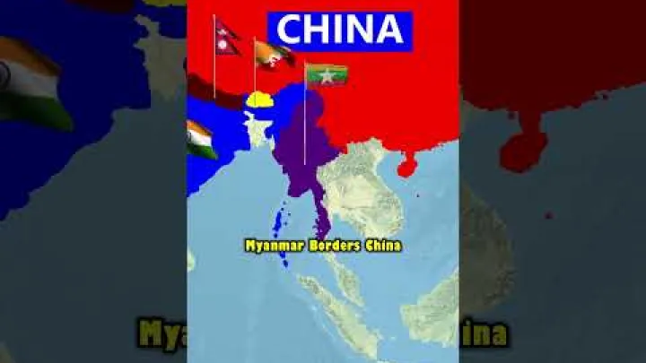
China neighboring countries are easiest to understand when land borders and maritime relationships are kept separate. China shares land borders with 14 sovereign countries, stretching from the Korean Peninsula and the Russian Far East across Mongolia and Central Asia to the Himalayas and mainland Southeast Asia. This guide lists all 14 countries, groups them by geographic region, and explains why some sources mention 16 or 17 neighbors. It also covers approximate border-length measurements, maritime neighbors, and disputed frontiers.
How Many Countries Border China?
The standard geographic answer is 14 countries. This count includes only sovereign states that share a terrestrial boundary with China. It does not include countries connected to China only by sea, and it does not treat Hong Kong or Macao as foreign countries.
The 14 Countries That Share a Land Border With China
Starting in the northeast and moving westward and then southward around China's frontier, the 14 land-bordering countries are:
- North Korea
- Russia
- Mongolia
- Kazakhstan
- Kyrgyzstan
- Tajikistan
- Afghanistan
- Pakistan
- India
- Nepal
- Bhutan
- Myanmar
- Laos
- Vietnam
This is the commonly used sovereign-country list. A geographic profile from the CIA provides broader context for China's mountainous, plateau, basin, and lowland geography, which helps explain why the country's borders vary so greatly by region.
The list excludes China's internal administrative boundaries with Hong Kong and Macao. Those boundaries are real land boundaries on a map, but they are not international borders with sovereign neighboring countries. The list also excludes maritime neighbors such as South Korea and Japan.
Why Some Lists Mention 16 or 17 Neighbors
Alternative counts usually combine different categories. One list may count the 14 foreign countries with land borders and then add Hong Kong and Macao as separate neighboring jurisdictions. That produces 16 entities, but not 16 sovereign countries bordering China.
Another list may add maritime neighbors to the 14 land neighbors. Adding two maritime states can also produce 16, while a broader maritime list can produce 17 or another number. The result depends on which coastal states, disputed waters, islands, or administrative entities the source includes.
- Land neighbor: A sovereign country connected to China by a terrestrial boundary.
- Internal administrative boundary: A boundary between mainland China and a Chinese special administrative region, such as Hong Kong or Macao.
- Maritime neighbor: A country connected to China through nearby, adjacent, or overlapping sea areas rather than through a land border.
Therefore, 16 or 17 is not a second accepted answer to the question “How many countries border China by land?” The answer to that specific question remains 14. Maps may show more names because they display administrative regions, islands, maritime claims, or other geographic entities in addition to sovereign land neighbors.
China's Land Neighbors by Geographic Region
The 14 countries form a nearly continuous arc around China. Dividing them into broad geographic regions makes a political or physical map easier to read, although the regional groupings are descriptive rather than official.
Northern and Northeastern Neighbors
Mongolia, Russia, and North Korea form the northern and northeastern group. Mongolia lies across the broad steppe north of China, while Russia occupies the northern and northeastern arc. North Korea connects China to the Korean Peninsula in the northeast.
The Yalu River and Tumen River are useful map anchors in the China–North Korea–Russia area. A river segment can still be part of a land boundary; the presence of water does not make a country a maritime neighbor. The nearby Yellow Sea is a separate maritime setting, which is why South Korea is not included in the 14-country land list.
These northern borders pass through a mixture of steppe, forest, river basins, and remote frontier areas. Their physical settings are different from the high mountain borders farther west, but all three countries count in exactly the same way: each shares a terrestrial boundary with China.
Western and Central Asian Neighbors
Kazakhstan, Kyrgyzstan, Tajikistan, and Afghanistan lie along China's western frontier, largely in and around Xinjiang. Kazakhstan is to the northwest, while Kyrgyzstan and Tajikistan are associated with the Tien Shan and Pamir mountain systems. Afghanistan has a narrow geographic connection with China near the Wakhan Corridor.

This part of the border combines deserts, high plateaus, mountain valleys, and glaciated ranges. The Tien Shan helps orient the northern part of the region, while the Pamir area is a useful reference for the meeting zone between Central and South Asia. These physical features explain why many western boundary areas are remote and difficult to survey.
Trade routes, historic corridors, and proximity to another country do not create an additional land border. Only the actual terrestrial boundary between China and a sovereign state counts for the 14-country total.
Himalayan Neighbors
Pakistan, India, Nepal, and Bhutan form the Himalayan and sub-Himalayan group. The frontier runs through some of the world's highest mountain environments, with major geographic anchors in the Himalayas and the high plateaus to their north.

Pakistan lies at the western end of this mountain frontier. India has a long and politically sensitive boundary with China. Nepal lies along the central Himalayan section, and Bhutan is farther east. All four countries belong in the land-neighbor list, but their boundary situations are not identical.
Nepal's boundary is generally treated as a defined international boundary for geographic-list purposes. By contrast, the entire China–India frontier is not covered by a mutually agreed, fully demarcated line, and some sections of the China–Bhutan frontier remain unresolved. These differences should not be hidden by describing all Himalayan borders as one general dispute.
Southern Neighbors in Mainland Southeast Asia
Myanmar, Laos, and Vietnam make up China's southern land-border group. Myanmar lies southwest of China, Laos is farther south, and Vietnam is to the southeast. Much of this frontier is associated with Yunnan and Guangxi, where mountain, forest, valley, and river landscapes shape the border region.
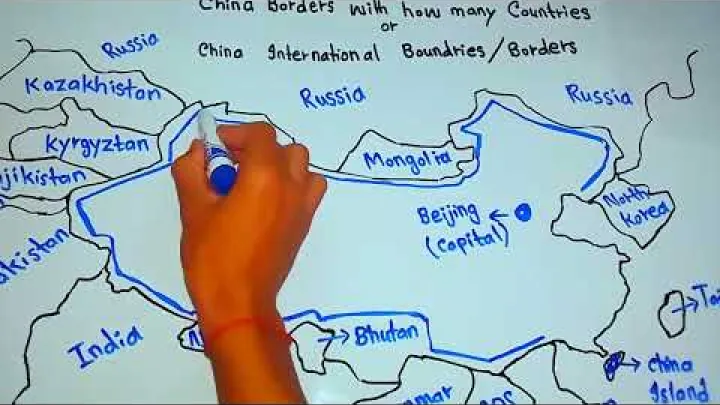
Vietnam is both a land neighbor and a maritime neighbor of China. Its land border must be counted separately from disagreements or overlapping claims in the South China Sea. The two categories describe different geographic relationships and should not be merged.
The southern borders also show why geographic regions should not be confused with political groupings. China, Myanmar, Laos, and Vietnam share mainland boundaries, but nearby sea areas create a separate maritime map with additional states.
China Border Lengths and Measurement Caveats
Border counts are more consistent than border-length totals. A country can be identified as a land neighbor even when different authorities measure the boundary in different ways.
Approximate Border Lengths: What Can Be Compared
A border-length figure should state what it measures. A useful definition is the terrestrial boundary between China and one sovereign neighboring country, measured in kilometers. That definition should also state whether river boundaries, junctions, disputed sectors, or separately administered areas are included.
Measurements can change because a survey follows a different line, a map uses a different scale, or a source treats a disputed section differently. Mountain ridges and river channels can also create technical differences. For this reason, a full ranking of China's 14 land borders can be misleading if each figure comes from a different definition.
A responsible reference should publish a figure only when the source is reliable and the measurement convention is clear. When evidence is not comparable, it is better to describe a border as long, short, or geographically narrow without adding false precision. Hong Kong and Macao should not appear in a country-to-country border-length table, and maritime boundaries should not be mixed with land-border measurements.
- Use kilometers consistently and identify any converted miles figure as an approximation.
- State whether the figure follows an agreed, administered, claimed, or disputed line.
- Separate the 14 sovereign-country borders from internal boundaries.
- Avoid ranking borders when the underlying measurements use different definitions.
Why Border-Length Figures Differ
The China–India frontier provides a clear example of why reported figures differ. An analysis by the SNU Himalayan Studies Centre discusses an Indian Ministry of Home Affairs figure of approximately 3,488 kilometers for the Line of Actual Control and compares it with approximately 4,056 kilometers for an international-boundary measurement. Rounded broadly, that is a comparison of about 3,500 kilometers and about 4,100 kilometers under different definitions, not an agreed range for one fully demarcated line.
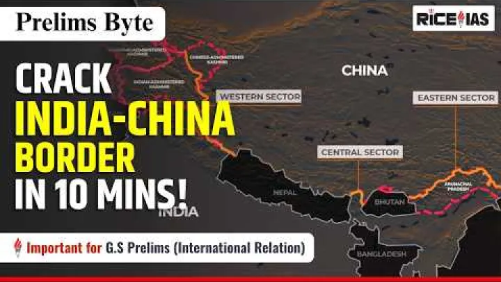
The Line of Actual Control, or LAC, describes the line separating areas of actual control in the China–India border area. An international-boundary measurement instead relates to the boundary claimed or recognized within a different legal and geographic framework. The two figures therefore answer different questions.
When quoting a border length, readers should be told which authority produced it and which line was measured. A neutral explanation should also say whether disputed sectors are included. This approach is more useful than presenting one number as universally correct or using mixed figures to rank all 14 neighboring countries.
China's Maritime Neighbors and Adjacent Seas
China's coastline creates a second group of geographic relationships. These maritime neighbors should be discussed separately because a nearby coast, an overlapping maritime claim, and an agreed sea boundary are not the same thing as a land border.
The Yellow Sea and East China Sea
China's eastern coast faces the Yellow Sea and the East China Sea. A broad geographic overview from Britannica identifies the Yellow Sea and East China Sea as important parts of China's eastern setting.
South Korea is an important maritime neighbor in the Yellow Sea context, while Japan is a maritime neighbor across the East China Sea and nearby waters. Neither country belongs in the 14-country land-border list. Their presence on an east Asia map reflects maritime geography, not a terrestrial connection.
Maritime delimitation can involve coastlines, islands, overlapping zones, and competing interpretations of where a boundary should be drawn. A close coastline does not automatically mean that two countries have a final, mutually agreed maritime boundary. Island and sea-claim issues must also be kept separate from the simple question of which countries share land with China.
The South China Sea Maritime Context
The South China Sea adds several states to the broader maritime picture. Vietnam is both a land neighbor and a maritime neighbor. The Philippines, Malaysia, and Brunei are relevant coastal states in discussions of overlapping claims and maritime space, but none should be added to China's land-border total on that basis.
Indonesia also has a broader maritime relationship with China, including the waters around the Natuna area. Indonesia is not a land neighbor of China, and its inclusion in a South China Sea discussion does not mean that it is automatically a claimant in every island or maritime dispute in the region.
The nine-dash line is a contested claim framework associated with China's maritime position. It should not be described as an agreed international boundary. The Council on Foreign Relations describes China's broad claims as a source of continuing maritime disputes involving states including the Philippines and Vietnam.
Three questions should be separated when reading a South China Sea map: who claims an island or feature, who administers it, and how maritime zones should be delimited. A country may be involved in one of these questions without being involved in all of them.
How Maritime Boundaries Differ from Land Borders
There is no single maritime-neighbor list that functions exactly like the 14-country land-border list. Maritime relationships depend on the scope of the map and whether it shows coast-to-coast proximity, overlapping claims, agreed boundaries, or broader regional relevance.
| Category | Meaning | Treatment in the 14-country count |
|---|---|---|
| Land border | Terrestrial boundary between China and a foreign sovereign state | Included |
| Maritime neighbor | Nearby or overlapping sea geography involving China | Not added |
| Internal boundary | Boundary between mainland China and Hong Kong or Macao | Not a foreign-country border |
| Disputed frontier | Boundary or area with competing claims or incomplete agreement | Status must be stated |
The same country can appear in both categories. Vietnam is the clearest example: it shares a land border with China and is also part of the maritime geography of the South China Sea. South Korea and Japan, by contrast, are relevant to China's maritime setting without appearing in the land-border list.
The safest wording is to label each relationship directly. Say “land neighbor” for a terrestrial border, “maritime neighbor” for a sea relationship, and “disputed maritime claim” or “overlapping maritime zone” when the status is not mutually settled.
Disputed Borders and Recognition Issues
The existence of a geographic border and the legal status of every section of that border are related but separate questions. China is counted as sharing land borders with India and Bhutan even though some parts of those frontiers remain contested or unresolved.
The China-India Border and the Line of Actual Control
China and India do not have a mutually agreed, fully demarcated boundary across the entire frontier. The Line of Actual Control is used as a practical reference for areas of control, but it is not identical to every boundary claimed by either country.
In the western sector, Aksai Chin is administered by China and claimed by India. In the eastern sector, Arunachal Pradesh is administered by India and claimed by China. Chinese descriptions may refer to the claimed region as South Tibet; that is a term associated with China's position and should not be presented as a mutually accepted geographic name.
Using “administered by” and “claimed by” allows a map or article to describe control and competing positions without declaring sovereignty over a disputed area. It also explains why China–India border-length figures can vary: a measurement based on the LAC is not necessarily measuring the same line as a measurement based on a claimed international boundary.
The China-Bhutan Border
Bhutan is one of China's 14 land neighbors, even though sections of the China–Bhutan border remain unresolved. The basic geographic fact that the two countries share a land boundary should not be confused with the question of whether every section has been mutually agreed and demarcated.
The China–Bhutan issue should be described as a bilateral border matter, while its wider regional implications may involve India. That regional connection does not make India a party to every China–Bhutan boundary segment. Reports about talks, proposals, or arrangements should not be described as a final, mutually accepted boundary agreement without a current authoritative confirmation.
Neutral Terms for Claims, Administration, and Boundaries
Consistent vocabulary makes a sensitive map easier to understand:
- Land border: A terrestrial boundary between two states or between a state and a separately administered territory.
- Maritime boundary: A line at sea that has been agreed or is being considered between coastal states.
- Administered by: The authority that exercises practical control over an area. This wording does not by itself settle sovereignty.
- Claimed by: The state that formally or publicly asserts a position over an area or boundary.
- Disputed: A status in which competing claims or interpretations are not mutually accepted.
- Demarcated: A boundary that has been formally located, marked, or otherwise identified through an accepted process in the relevant section.
A map line should not automatically be treated as an agreed international boundary. Labels may show an administered area, a state claim, a proposed line, or a disputed frontier. The same careful terminology applies to both land disputes and maritime claims.
Recognition questions also do not change the basic method used for the 14-country list. The list identifies sovereign countries with a terrestrial connection to China; it does not attempt to settle every question of sovereignty, administration, or diplomatic recognition.
Conclusion: China's Neighboring Countries at a Glance
China shares land borders with 14 sovereign countries: North Korea, Russia, Mongolia, Kazakhstan, Kyrgyzstan, Tajikistan, Afghanistan, Pakistan, India, Nepal, Bhutan, Myanmar, Laos, and Vietnam.
For a clear geographic answer, keep the categories separate. South Korea, Japan, the Philippines, Malaysia, Brunei, and other coastal states belong to maritime discussions rather than the land-border count. Border lengths should be presented only with a stated measurement definition, and disputed areas should be labeled as claimed, administered, disputed, or demarcated instead of being described as universally settled.
Select area
Create a post
Posting is free and no registration is required.