Jolo Map: Sulu Location, Routes, and Town Layout
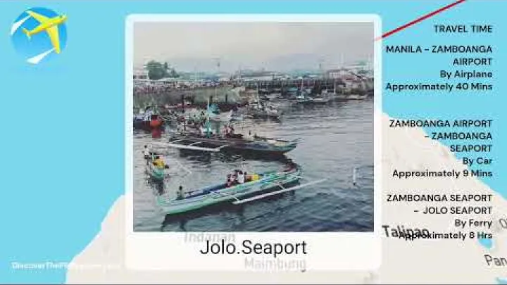
A Jolo map is most useful when it explains more than the shape of an island or the names of streets. Jolo is part of Sulu in the southern Philippines, and planning around it usually means understanding gateways, sea routes, local coordination, and the relationship between Jolo Island and Jolo town. This guide explains where Jolo is, how travelers commonly approach it through Zamboanga, what the town layout means for arrivals, and why current local information should always guide route decisions. Use it as an orientation tool before checking official advisories, transport operators, and local contacts.
Start with the Big Picture
Before zooming in on a town map, it helps to place Jolo within the wider geography of the Philippines. The most important planning idea is that Jolo is an island-area destination in Sulu, not a simple road extension from the larger Philippine travel network.
Where Jolo Is in the Philippines
This article covers Jolo in Sulu, Philippines. It does not refer to unrelated places, businesses, or map labels that may use the same name elsewhere.

Jolo is in the Sulu Archipelago, southwest of mainland Mindanao. In administrative terms, Sulu is part of the Bangsamoro Autonomous Region in Muslim Mindanao, often shortened to Bangsamoro or BARMM. For broad regional context, the Bangsamoro Government map is a useful starting point because it shows how Sulu fits into the wider autonomous region.
On a map of the Philippines, Jolo sits in a maritime chain between larger reference points such as Zamboanga, Basilan, and Tawi-Tawi. That location matters for planning. Straight-line distance can make Jolo look close to other islands, but actual travel depends on ferry operations, flight availability, weather, security conditions, and local permission or coordination.
Jolo Island, Jolo Town, and Sulu Province
The name Jolo can mean more than one thing. It may refer to Jolo Island, and it may also refer to the Municipality of Jolo, the capital town of Sulu Province. When a map label says “Jolo,” check whether it is pointing to the island as a whole, the town center, the airport area, the port, or another local feature.
A simple hierarchy is helpful: Philippines, Bangsamoro, Sulu Province, Jolo Island, and the Municipality of Jolo. Sulu is the province. Jolo Island is the main island associated with the provincial capital. Jolo town is the compact urban and administrative anchor that most visitors, project teams, and transport planners will use first.
For clear writing and safe planning, it is better to call Jolo a town or municipality unless a specific source uses a different term. This avoids confusion with Philippine cities that have different administrative status and different transport expectations.
What a Useful Jolo Map Should Show
A useful Jolo map should show more than roads. It should help you understand gateways, ports, airport access, the town core, and how coastal movement shapes travel around the island. For many readers, the most important map features are Jolo Port, Jolo Airport, the Sulu Provincial Capitol, Jolo Town Hall, and the larger staging gateway of Zamboanga City.
For Jolo, a map is also a verification tool. It can show where places are, but it cannot confirm that a route is operating, suitable, open to visitors, or appropriate under current conditions. A road shown on a digital map may not be the right route for a visitor on a particular day. A boat line seen on a route page may require updated confirmation before travel.
Treat public maps as a mental model, not as final permission to move. The best map-based plan combines broad geography with current transport checks, local advice, and official guidance.
Getting to Jolo: Main Route Logic
Most practical route planning for Jolo follows a hub-and-spoke pattern. Travelers first reach a larger Philippine gateway, usually Zamboanga City, and then continue toward Jolo by verified sea or air option when available.
Zamboanga as the Practical Gateway
Zamboanga City is the main practical gateway for many Jolo routes because it connects wider Philippine transport networks with Sulu. Travelers coming from Manila, Cebu, Davao, or other major cities usually plan around a domestic connection to Zamboanga before continuing to Jolo.
Route overview services such as Rome2rio commonly point readers toward the Zamboanga connection for Jolo access. Use that kind of route page for broad orientation only. It should not replace confirmation from transport operators, terminals, airports, ports, or trusted local contacts.
The safest way to read the map is as a chain of staging points: your origin city, Zamboanga International Airport or another Zamboanga arrival point, Zamboanga port or onward air connection, and then Jolo Port or Jolo Airport. Avoid assuming that all legs can be completed on the same day. Schedule changes, boarding rules, weather, or local restrictions can affect the journey.
Sea Access Between Zamboanga and Jolo
The Zamboanga to Jolo sea corridor is a major transport axis for passengers, goods, and local movement. On a transport map, this corridor is often more important than small road details because it explains how many people actually enter Sulu from the wider Philippine network.

Different vessel categories may appear in route discussions, including ferry, RORO, and fastcraft. Treat those as broad categories unless you have current operator information. Do not rely on old blog posts, old screenshots, or map summaries for fares, departure times, sailing frequency, or boarding rules.
| Route element | What the map shows | What to verify |
|---|---|---|
| Zamboanga to Jolo sea route | Main maritime connection | Current sailing, ticket rules, boarding time, identification, baggage, and cancellation policy |
| RORO option | Possible passenger and vehicle route category | Vehicle carriage, loading rules, space, and operator status |
| Fastcraft or ferry option | Passenger sea route category | Operating day, check-in cut-off, sea condition updates, and arrival arrangements |
| Jolo Port arrival | Sea-entry anchor in town planning | Pickup plan, local guidance, and onward movement approval |
Before choosing a sea route, confirm sailing schedules, ticketing process, port requirements, passenger identification rules, sea conditions, and any security-related restrictions. This should be done close to the travel date because route availability can change faster than online maps update.
Air Access Through Jolo Airport
Jolo Airport serves the general Jolo area. Its presence on a map is important because it shows that air access may be part of a route plan, but it does not mean flights are always operating on the dates you need. The basic identification of the airport is widely listed, including by Wikipedia, but travelers should check current airline, airport, or local authority information before building a plan around it.
When flights are available, air access can reduce travel time compared with a sea crossing. However, frequency, route availability, baggage rules, and operational status may change. Confirm the route directly rather than assuming that an airport pin means a usable flight.
Also plan the last mile. Jolo Airport is not the same thing as the town core, your lodging, or your meeting place. Arrange pickup or local transport before arrival, especially if you are visiting for work, research, humanitarian activity, government coordination, or any purpose that requires hosted movement.
Jolo Town Map: Core Areas and Landmarks
For most first-time users, the most useful Jolo town map is not a full street-by-street itinerary. It is a set of stable anchors that help you understand arrival, lodging, government coordination, and short local movement.
Port Area and Arrival Orientation
Jolo Port is the main sea-arrival anchor and a logical first point on a Jolo town map. If you arrive by ferry or other passenger vessel, the port area is where your map-based plan becomes a real movement plan.
The port area connects passenger movement, cargo activity, local transport, and nearby commercial activity. It is not only a point on the shoreline. It is also a place where timing, pickup, luggage handling, and onward coordination matter.
Do not assume you can arrive and independently decide the rest of your route. Arrange onward pickup, lodging confirmation, or local guidance before arrival. Keep port references general in your planning and avoid relying on detailed assumptions about port operations.
Government and Administrative Core
The Sulu Provincial Capitol and Jolo Town Hall are useful mental-map anchors in the town center. They help readers understand where the administrative core is, even if they are not visiting those buildings directly.
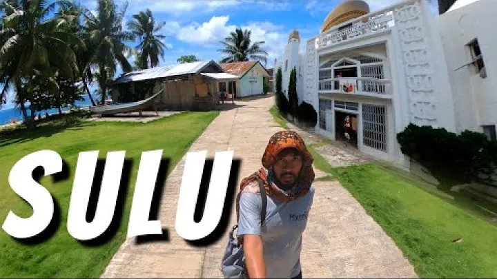
Local traveler accounts, including Kotheexplorer, have described town landmarks such as Jolo Town Hall. Treat such accounts as local orientation, not as a guarantee of access, opening conditions, or suitability for unescorted visits.
For official, hosted, or project-related travel, coordination may involve government offices, local contacts, or institutional hosts. The administrative core is important for navigation and planning, but a map pin does not guarantee that a visitor can freely enter a building or obtain a service without prior arrangement.
Markets, Lodging Clusters, and Short Urban Trips
In compact Philippine town centers, markets, small hotels, guesthouses, transport stands, eateries, and basic services often cluster near central roads and arrival points. In Jolo, readers should use that general pattern cautiously and verify current lodging, pickup, and local movement plans before arrival.
Tulay Mosque is a notable town landmark that may appear on maps and local descriptions. If you plan to pass by or visit nearby areas, confirm local access, appropriate behavior, timing, and whether guidance is recommended. Do not assume every landmark is open, accessible, or suitable for casual sightseeing on the day you arrive.
For short urban trips, tricycles and other local transport may be relevant where local conditions allow. The practical rule is simple: confirm where you are going, arrange transport through a trusted contact when possible, and avoid turning a map pin into an independent walking or riding plan without local advice.
Moving Around Jolo Island
Jolo Island movement is shaped by geography and current conditions. A map can help you understand the island layout, but it should not be used to create fixed routes without local confirmation.
Coastal Road Pattern and Island Layout
Jolo Island has a rugged interior, and many settlements are easier to understand through coastal or near-coastal access patterns. On a broad island map, the town of Jolo sits as the main urban anchor, while other municipalities and communities form part of the wider island geography.

Names such as Patikul, Parang, Maimbung, and Omar may help you read an island map. They should be treated as orientation names, not automatic visitor routes. The same applies to any road that appears to connect coastal areas or inland points.
Island travel can be affected by road condition, weather, security coordination, local approval, and daylight timing. A responsible map plan asks, “Is this route appropriate today, for this traveler, with this purpose and local guidance?” It does not ask only, “Does a road appear on the map?”
Town Transport and Hired Vehicles
For many short-distance movements in and around town, tricycles, motorcycles, and hired vehicles are more relevant than formal urban transit systems. The exact mode depends on distance, purpose, timing, and local conditions.
Arrange drivers through trusted local contacts, hosts, accommodation staff, official tourism channels where available, or institutional coordinators. This is especially important for visitors who are not familiar with Sulu, do not speak local languages, or are traveling for work that requires official coordination.
Do not rely on old fare information. Fares, availability, and suitable pickup points can change. Checkpoints, timing, route approval, and the need to return before dark can also affect movement. Daylight travel and pre-arranged pickup are practical safeguards, but they are not a substitute for current advice.
Boats to Nearby Islands and Coastal Stops
A map of the Sulu Archipelago can make nearby islands and coastal points look easy to reach. Local residents may use small boats or bancas for regular movement, and scheduled inter-island transport may exist on some corridors. Visitors should not treat every visible sea route as an open tourist route.
Distinguish scheduled inter-island transport from informal or small-boat movement. Scheduled services require current confirmation. Small-boat trips require even more caution because weather, sea conditions, local permission, and safety arrangements matter greatly.
Any offshore or coastal stop should be arranged through appropriate local guidance and current official advice. Avoid independent island-hopping plans unless they are clearly supported by reliable local coordination and current conditions.
Safety and Official Coordination
In Sulu, the most important map rule is that current guidance outranks static information. This section is not meant to be alarmist. It is meant to keep the map useful by connecting geography with real decision-making.
Why Static Maps Are Not Enough in Sulu
A route that appears on a map may not be appropriate, open, or recommended for visitors at a given time. This is especially important in Jolo and Sulu, where security conditions, access rules, local events, and transport operations can affect movement.
Current official advisories, Philippine and local authority guidance, host instructions, and on-the-ground information should outrank a static map. This applies to roads, port movement, airport transfers, town visits, coastal stops, and trips outside the urban core.
A balanced approach is best. Do not assume that everything is closed or unsafe, and do not assume that everything shown on a map is available. Use a map to understand location, then use current coordination to decide whether and how to move.
Pre-Travel Checks Before Choosing a Route
Before choosing a route to Jolo, build a verification checklist. Do this close to the travel date, not only weeks in advance.
- Check current travel advisories from your government and relevant Philippine or local authorities.
- Confirm whether official tourism, local government, host, or institutional coordination is required or recommended.
- Verify ferry, fastcraft, RORO, or flight operation directly with the operator, terminal, airport, port, or trusted local contact.
- Confirm accommodation, pickup, and arrival timing before you depart for Jolo.
- Check identification, ticketing, baggage, and vehicle carriage rules if applicable.
- Plan the return route before you arrive, including buffer time for missed sailings or cancellations.
- Allow extra time for weather disruption, sea conditions, schedule changes, or security-related delays.
This checklist is more useful than a fixed itinerary because conditions can change. A good Jolo map plan has alternatives and buffer time.
Using Google Maps and Tourist Maps Carefully
Digital maps and tourist maps are helpful for broad orientation. They can show the relationship between Jolo Island, Jolo town, the port, the airport, main roads, and recognizable landmarks. They are especially useful before you speak with a local contact because they give you a shared vocabulary.
However, map pins, minor roads, walking routes, and small boat routes may be incomplete, outdated, or unsuitable for visitors. A route that looks short on a phone screen may involve conditions that the map cannot evaluate.
Use digital maps together with local confirmation. Maps can answer “Where is it?” They cannot always answer “May I go there?”, “Is this route operating?”, “Is this appropriate today?”, or “Who should guide the movement?”
Map-Based Planning Examples
The following examples show how to think with a map without turning it into a rigid itinerary. They are conservative planning models, not guarantees that a route will work every day.
A Simple Access Plan from Manila or Cebu
A simple access plan starts from a major Philippine gateway such as Manila or Cebu. From there, the traveler connects to Zamboanga, then continues to Jolo by a verified sea or air option when available.
On a map, this looks like a chain rather than a single direct trip: major city, Zamboanga, Jolo. This is the hub-and-spoke logic that makes route planning easier. It also helps you identify where delays may happen and where you may need an overnight buffer.
If flight and ferry or onward flight schedules do not align, plan to overnight in Zamboanga rather than forcing a same-day connection. This is especially important if you have meetings, onward flights, or official appointments after Jolo.
A First-Day Orientation Plan in Jolo Town
A cautious first-day sequence in Jolo town begins with arrival and coordination. If arriving by sea, start from Jolo Port. If arriving by air, start with the airport transfer. In both cases, meet your arranged pickup or local contact first.
After arrival, confirm lodging, check your next-day plan, and coordinate with any relevant local offices, host organizations, or contacts. If current conditions allow, make only short approved town movements on the first day. Possible orientation points may include the port area, Sulu Provincial Capitol, Jolo Town Hall, markets, or Tulay Mosque, but only if access and movement are locally confirmed.
The first day should prioritize orientation, communication, and practical setup over ambitious sightseeing. This approach is useful for tourists, researchers, project staff, journalists, consultants, and anyone entering a place where local coordination matters.
A Conservative Day-Trip Radius from Jolo
For trips outside the town core, think in terms of a conservative radius rather than a list of attractions. The question is not only how far a place looks on the map. It is whether the route, timing, approval, return plan, and conditions make sense on that day.
A practical day-trip radius depends on road time, local approval, security coordination, weather, sea conditions if boats are involved, and the need to return with enough daylight. Exact destinations outside the town core should be confirmed locally.
This approach avoids the common mistake of ranking remote beaches, villages, or coastal stops based only on visual appeal. In Jolo, good planning is less about collecting pins and more about choosing movements that are verified, appropriate, and realistic.
What to Verify Before You Rely on Any Jolo Map
Before using any Jolo tourist map, city map, or transport map for real travel, check the details that a map cannot guarantee. The following items are the main decision points.
Transport Schedules, Tickets, and Passenger Rules
Verify ferry, fastcraft, RORO, and flight operation directly with operators, ports, terminals, airports, or trusted local contacts. Do not rely only on an old travel article, a route aggregator, or a saved screenshot.
Ask about fare, boarding cut-off, passenger identification, baggage limits, vehicle carriage if needed, cancellation policy, and what happens if weather or operations change. International visitors should also confirm whether passports or other identification are required at each stage of travel.
Route availability can change faster than online map pages update. A map can show the corridor, but the operator or local authority confirms whether you can use it.
Accommodation, Pickups, and Local Contacts
Confirm that your lodging is operating, reachable, and appropriate for your travel purpose. Online booking availability does not always answer the more important questions: who will meet you, how you will get there, whether the location fits your movement plan, and what local coordination is needed.
Arrange pickup before arriving at Jolo Port or Jolo Airport. Share your arrival time with the person or organization meeting you, and have a backup communication plan if schedules change.
Local contacts may be necessary to confirm access rules, route suitability, office visits, project sites, or day movements. Treat accommodation choice as part of the transport plan, not only a comfort decision.
Weather, Sea Conditions, and Return Timing
Weather and sea conditions can affect ferries, fastcraft, small boats, and even road or transfer timing. Avoid planning a critical onward flight or appointment immediately after an expected return crossing.
Build buffer time into both directions of travel. If you must be in Zamboanga, Manila, Cebu, or another city by a fixed date, leave extra space for missed sailings, cancellations, delays, or last-minute changes.
Before any sea crossing or offshore movement, check current weather, port guidance, operator information, and local advice. The practical rule is simple: check, buffer, and avoid last-minute critical connections.
Frequently Asked Questions
Where is Jolo on a map of the Philippines?
Jolo is in Sulu, in the Sulu Archipelago southwest of mainland Mindanao. It is part of the Bangsamoro Autonomous Region in Muslim Mindanao and is commonly planned through the Zamboanga travel corridor.
Is Jolo an island, a town, or a province?
Jolo can refer to Jolo Island and to the Municipality of Jolo. The province is Sulu, and Jolo town is the provincial capital and main urban anchor on the island.
What is the main route to Jolo from the rest of the Philippines?
The main route logic is to reach Zamboanga first, then continue to Jolo by verified sea transport or by air when flights are operating. Always confirm schedules and rules before travel.
Can visitors travel around Jolo independently?
Visitors should not rely on independent map-based movement alone. Local guidance, current advisories, host coordination, and transport confirmation are important, especially outside the town core.
What should I verify before relying on a Jolo tourist map?
Verify transport schedules, port or airport rules, accommodation, pickup arrangements, local contacts, current advisories, weather, sea conditions, and your return route. A tourist map is useful for orientation, but it cannot confirm current access or suitability.
Conclusion: Use a Jolo Map as a Planning Tool
A good Jolo map helps you understand the relationship between the Philippines, Bangsamoro, Sulu Province, Jolo Island, and Jolo town. It also shows why Zamboanga is such an important gateway and why Jolo Port, Jolo Airport, the Sulu Provincial Capitol, and Jolo Town Hall are useful orientation anchors.
The map should be the beginning of your plan, not the final authority. Before traveling, confirm current advisories, transport operation, accommodation, pickup, local coordination, weather, sea conditions, and return timing. In Jolo, the best route is not only the one that appears shortest on a map. It is the one that is current, coordinated, and appropriate for your purpose.
Select area
Create a post
Posting is free and no registration is required.