Singapore Neighboring Countries: Malaysia and Indonesia
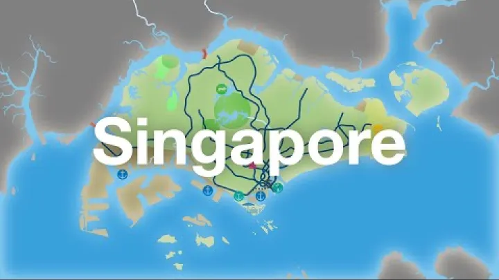
Singapore’s neighboring countries are Malaysia and Indonesia, but the answer needs one important clarification: Singapore has no land borders. Its direct international boundaries are maritime boundaries, drawn in the waters around the island and its outlying features. Malaysia is immediately north across the Strait of Johor, while Indonesia is south across the Singapore Strait, especially in the direction of the Riau Islands. Understanding the difference between a land border, a sea border, and a fixed crossing makes a Singapore map much easier to read.
The Short Answer: Singapore Has Two Maritime Neighbors
In geographic terms, Singapore directly neighbors two countries: Malaysia and Indonesia. Both relationships involve maritime boundaries rather than a shared stretch of dry land.
Singapore Has No Land Borders
Singapore has zero land borders. It is an island state, and water separates its territory from every other country. A land border normally exists where the territories of two states meet on land; Singapore has no such boundary.

This can seem confusing because travelers can cross between Singapore and Malaysia by road and rail. The Johor–Singapore Causeway and the Malaysia–Singapore Second Link are fixed crossings over the Strait of Johor, with immigration and customs checkpoints at each end. They connect the two countries physically, but they do not turn the waterway or the international boundary into a conventional land border.
For this article, a neighboring country means a state that shares a direct international boundary with Singapore. That definition includes a maritime border, which is why Malaysia and Indonesia are Singapore’s direct neighbors.
Malaysia and Indonesia Are the Direct Neighbors
Singapore’s two maritime neighbors can be understood with a simple north-and-south view:
| Country | Direction from Singapore | Adjacent waterway | Border type |
|---|---|---|---|
| Malaysia | North | Strait of Johor | Maritime boundary |
| Indonesia | South | Singapore Strait | Maritime boundary |
Malaysia lies across the narrow Strait of Johor, opposite Singapore’s northern coast. Indonesia lies across the Singapore Strait, with the Indonesian Riau Islands forming the main nearby island group to the south. Neither border is a land border, even where bridges or other infrastructure make the separation look less obvious on a map.
Singapore's Border with Malaysia
The Singapore–Malaysia boundary is most visible north of Singapore, where the Strait of Johor separates Singapore from the Malaysian state of Johor. It combines an everyday crossing point for people with a legally distinct maritime frontier.
The Strait of Johor and the Crossings to Malaysia
The Strait of Johor, also called the Johor Strait, is the waterway between Singapore and Johor in peninsular Malaysia. A boundary in this strait has long defined the separation between the two territories. The National Library Board Singapore notes that a 1927 territorial waters agreement specified an international boundary line in the strait, with later boundary arrangements addressing particular areas.
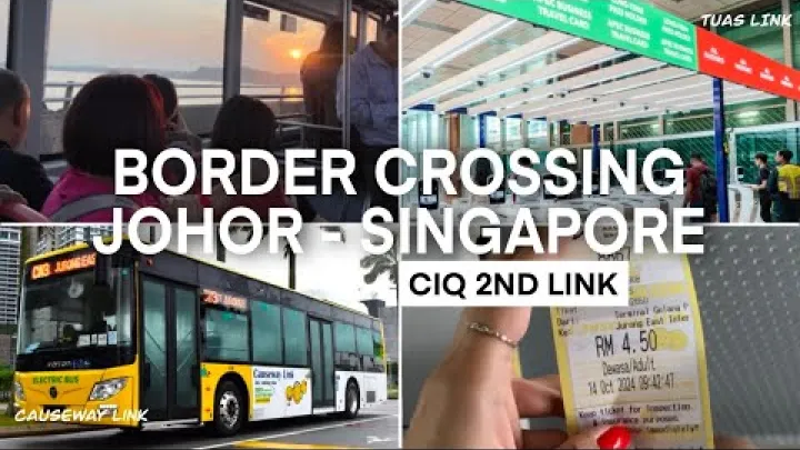
Two major fixed crossings span the waterway. The Johor–Singapore Causeway links Singapore with Johor Bahru, and the Malaysia–Singapore Second Link connects western Singapore with the Johor area. They support road travel, and the Causeway also carries rail infrastructure. These structures are routes across water, not proof of a shared land frontier. Border control remains necessary because travelers are moving between two sovereign states.
The detailed history of the boundary includes agreements and technical adjustments, but the practical geographic point is straightforward: Malaysia is Singapore’s northern maritime neighbor across the Strait of Johor.
Pedra Branca and the Eastern Maritime Boundary
At the eastern approach to the Singapore Strait are small maritime features known as Pedra Branca, Middle Rocks, and South Ledge. Their location makes them relevant to the wider Singapore–Malaysia maritime setting, even though they are far from the Causeway crossings.

In 2008, the International Court of Justice decided that sovereignty over Pedra Branca belonged to Singapore and sovereignty over Middle Rocks belonged to Malaysia. South Ledge is a low-tide elevation, and its status is linked to the territorial waters generated by the surrounding features. The Singapore Ministry of Foreign Affairs provides an official overview of these features and the case.
It is important to treat that judgment as a decision about sovereignty over specific features, rather than as a complete settlement of every maritime boundary question in the surrounding waters. Maritime delimitation can involve separate technical and legal processes. For detailed legal questions, consult current official information rather than relying only on a simplified map.
Singapore's Border with Indonesia
Indonesia is Singapore’s southern maritime neighbor. The border is shaped by the busy waters of the Singapore Strait and by the position of Indonesian islands close to Singapore’s southern side.
The Singapore Strait and Indonesia's Riau Islands
Look south from Singapore on a regional map and you reach the Singapore Strait. Beyond it are parts of Indonesia’s Riau Islands, which provide the clearest local reference for Indonesia’s position opposite Singapore. This is why Indonesia, not Thailand or another nearby Southeast Asian country, is a direct maritime neighbor.
The Singapore–Indonesia frontier is entirely maritime. There is no land connection and no fixed bridge or causeway crossing between the two countries. The waters form part of a wider regional maritime corridor. The Singapore Strait is connected geographically with the Strait of Malacca, but the latter name should not be mistaken for a separate Singapore–Thailand border area.
How the Maritime Boundary Was Defined
Singapore and Indonesia have defined parts of their territorial sea boundary through agreements made in stages. The principal sections are commonly described as central, western, and eastern segments, associated with agreements concluded in 1973, 2009, and 2014. In plain language, these agreements establish where the two countries’ territorial waters meet in the relevant areas.
A territorial sea boundary is a specific type of maritime boundary. It should not automatically be treated as a complete definition of every possible maritime zone or every technical issue that may arise farther offshore. The U.S. Department of State provides material on the Indonesia–Singapore territorial sea boundary and its geographic setting. For most readers, the key fact is that Indonesia directly borders Singapore by sea across the Singapore Strait.
Nearby Countries Versus Neighboring Countries
“Nearby” and “bordering” are not the same term. A country can be easy to reach, part of the same region, or visible on a broad map without sharing an international boundary with Singapore.
Why Thailand and Other Nearby States Are Not Direct Bordering Countries
Thailand is in the wider regional setting of the Malay Peninsula and the Strait of Malacca, but it does not directly border Singapore by land or sea. There is Malaysian territory and maritime space between the two countries. Therefore, Thailand may be described as nearby or regional, but not as one of Singapore’s bordering countries.
The same distinction applies to other Southeast Asian states that may be familiar travel destinations. Proximity, flight connections, ferry access, or regional membership do not create a direct boundary. For Singapore, the complete list of direct neighboring countries remains Malaysia and Indonesia.
How to Read a Singapore Neighboring Countries Map
A simple map can answer the question quickly. Look north of Singapore for Malaysia across the Strait of Johor. Look south for Indonesia across the Singapore Strait and toward the Riau Islands. Labeling both countries as maritime neighbors helps prevent the common assumption that Singapore has a land border with Malaysia.
On detailed maps, the Causeway and the Second Link can look like continuous land connections. Read them as transport infrastructure crossing a waterway, not as a change in the legal classification of the border. For a clear student or general-reference map, mark the Strait of Johor, the Singapore Strait, Malaysia, Indonesia, and the two major crossings; precise boundary lines require a specialist nautical or official boundary map.
Key Takeaway
Singapore has no land borders. Its only direct neighboring countries are Malaysia to the north, across the Strait of Johor, and Indonesia to the south, across the Singapore Strait near the Riau Islands. The Causeway and Second Link connect Singapore with Malaysia, but both countries still meet across a maritime boundary. Countries such as Thailand may be regionally nearby, yet they do not directly border Singapore.
Select area
Create a post
Posting is free and no registration is required.