Viqueque Best Time to Visit: Weather & Seasons
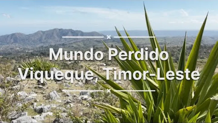
Choosing the best time to visit Viqueque is mainly a question of rainfall, road access, and outdoor reliability rather than a large change in temperature. Viqueque is warm throughout the year, but conditions on Timor-Leste’s south coast can change the ease of rural travel, river crossings, coastal activities, and hiking. This guide explains the dry and wet seasons, gives a month-by-month planning view, and matches different travel goals with the most suitable periods. Climate averages can help you choose dates, but current forecasts and local access information should guide decisions close to travel.
The Quick Answer: Best Time to Visit Viqueque
For most visitors, the best time to visit Viqueque is approximately May to October. June to September is the strongest all-purpose period if you want the most dependable conditions for rural roads, hiking, coastal outings, and photography. May and October can be useful shoulder-month choices because they may offer a balance between improving access and greener scenery.
Best Overall Window
Choose June to September for the simplest itinerary. These months generally bring less rain, more usable outdoor days, clearer views, and fewer weather-related interruptions than the core wet season. They are especially suitable if your visit includes travel beyond Viqueque town, where rural roads, bridges, and hilly routes can have a greater effect on the schedule.

May and October deserve a separate consideration. They are often treated as transition months, so conditions can be more variable than in the middle of the dry season. May may still bring rain but can look greener, while October may retain relatively reliable access before rainfall becomes more frequent. Some national descriptions use May to November for the dry season, while others use June to October. The broad seasonal pattern is summarized by Timor-Leste Geography & Climate, but local timing can vary from year to year.
This is a recommendation for most travelers, not a universal rule. A visitor who dislikes heat may prefer a shorter outdoor schedule and early starts. Someone planning a fixed road-based itinerary should favor the more reliable middle dry-season months. A traveler with a long stay, strong local support, and a specific reason to see green landscapes may accept more uncertainty.
When the Wet Season May Still Suit You
January to March is usually a poor fit for a short itinerary with fixed road travel. It is generally the wettest part of the year in available Viqueque planning summaries, and heavy rain can bring cloud, muddy routes, flooding, landslides, and delays. The problem is not only whether rain falls during a planned activity. Rain in a wider rural catchment can affect a bridge, river, or road farther along the route.
Wet-season travel is not automatically impossible. It may suit visitors who want greener landscapes, a quieter atmosphere, or a longer and flexible stay. It can also be reasonable when the purpose of the visit is important enough to accept changed plans. The risk is higher when accommodation, transport, excursions, or onward connections are booked tightly. Treat this period as a flexibility decision rather than an absolute prohibition.
Viqueque Weather and Climate by Season
Viqueque weather follows the broad monsoonal pattern of Timor-Leste, but local conditions can differ between the south coast, lowlands, and higher inland terrain. Historical climate information is useful for comparing months, not for predicting a particular day. The World Bank’s Climate Change Knowledge Portal presents a 1991–2020 historical climatology baseline and emphasizes that such information should be used as reference context.
Dry Season: May or June to October or November
The dry season is the preferred period for most travel to Viqueque. Rainfall is generally lower, skies are often clearer, and outdoor plans are more likely to proceed without major weather disruption. Rural access is usually more predictable than in the wet season, although a dry-season trip can still involve rough surfaces, delays, and difficult driving.
July to September appear to be the most consistently dry months in the available climate summaries, with August often identified as the driest point. This should be read as a climate tendency, not a guarantee of rain-free days. A dry-season itinerary still needs protection from strong sun, heat, and humidity.
There is also a visual trade-off. The landscape may be less green later in the dry season, especially after a long period with little rain. If clear views and reliable access matter most, this is usually a good exchange. If lush vegetation and dramatic cloud formations matter more, May or October may be more appealing.
Wet Season: November or December to April or May
The wet season is usually described as beginning sometime between November and December and continuing into April or May. The difference between published boundaries is normal for a climate with a gradual transition. In practical terms, January through March is generally the period when rain and its travel effects deserve the most attention.
Wet-season days can feel hotter because humidity is higher and cloud cover may reduce relief from the heat. Rain may arrive as a short heavy shower or as a longer period that affects the rest of the day. Visibility can also decline in hills and along the coast.
For Viqueque, the main concern is access. Heavy rain can raise rivers, affect bridges, damage unsealed roads, and trigger washouts or landslides on hilly routes. A route may be passable in town while a rural connection farther away is not. This makes the wet season a logistical issue as much as a comfort issue.
Temperatures, Humidity, and Coastal-to-Upland Differences
Viqueque stays warm to hot during every season. Seasonal rainfall changes are more important than seasonal temperature changes, so moving from the wet season to the dry season does not create a cool season. As a broad national coastal reference, Timor-Leste tourism information describes many coastal areas as commonly ranging around 25–35°C, but this should not be treated as a precise Viqueque forecast.
Humidity changes how the temperature feels. A warm day with high humidity can make walking, waiting beside a road, or carrying luggage more tiring than the thermometer suggests. Plan for shade, water, breathable clothing, and slower activity during the hottest part of the day.
Conditions can feel different inland and at higher elevations within the municipality. Nearby upland areas may be cooler, cloudier, or wetter than the coastal and lowland base. These differences are not uniform, so pack a light extra layer for evening or elevated excursions without assuming that every highland location has the same climate.
Storms, Tropical Cyclones, and Year-to-Year Variability
Monsoon timing and rainfall intensity vary between years. Large-scale patterns such as El Niño and La Niña can influence when rain arrives and how strong a season becomes. A transition month that is relatively dry one year may be wetter or more unsettled the next.
Severe monsoon storms and possible tropical-cyclone influence can affect rain, wind, sea conditions, and road access. The available evidence does not establish a dependable Viqueque-specific cyclone calendar, so broad regional statements should not be used as a local forecast. April to May and October to November are best treated as variable transition periods.
Use climate information to select a general travel window, then check a current forecast and relevant warnings before departure and before rural excursions. This is particularly important when a trip falls near a seasonal boundary or includes exposed coastal activities.
How Weather Affects Getting to and Around Viqueque
Weather affects Viqueque travel most clearly through movement. The municipality includes town, coastal, rural, and inland settings, and the condition of roads, bridges, and river crossings can determine whether an attractive plan is practical on a particular day.
Roads, Bridges, and Rural Access
Heavy rain can damage or temporarily block rural roads and bridges. Unsealed surfaces may become muddy, while fast runoff can cut across roads or undermine a crossing. Landslides and washouts are especially relevant on hilly or poorly surfaced routes. These effects may continue after the rain has stopped because water levels and road conditions take time to improve.
The drier months normally improve reliability, but they do not turn every route into a fast or easy journey. Rough surfaces, construction, mechanical problems, traffic, and local delays can still affect a trip. A suitable vehicle and an experienced local driver are important when traveling beyond Viqueque town.
A hazard overview from CFE-DMHA describes flooding and other seasonal hazards affecting Timor-Leste. Before leaving Dili or traveling farther into the municipality, confirm current road, bridge, and river-crossing conditions with a reliable local contact. Allow buffer time rather than building a rural excursion around an exact historical travel duration.
Coast, Rivers, and Outdoor Conditions
The drier months are generally more suitable for beach outings, swimming, boating, and coastal photography because rain interruptions and cloud cover are less common. Clearer conditions can also improve the experience of looking across the water or photographing the coast. However, broad marine guidance for Timor-Leste is not the same as a Viqueque-specific sea forecast. Local wave, current, and visibility information may be limited.

Rain also affects inland water. Rivers can rise quickly after heavy rainfall, and currents may become stronger even when the weather at your location looks calm. Avoid swollen rivers, uncertain crossings, and exposed coastal water during or soon after heavy rain. For swimming or boating, follow current local advice and treat the day’s water conditions as a separate safety decision from general weather comfort.
Traveling from Dili to Viqueque
For most international visitors, Dili is the principal international arrival gateway. This means the weather along the wider overland itinerary matters, not only the conditions in Viqueque town. Rain in another part of the route can affect a departure, while a clear forecast at the destination does not guarantee an uninterrupted journey.
Coordinate arrival, onward road travel, and departure with extra time during wet or transitional months. Current route conditions and travel times are not sufficiently documented in the available information to support a guaranteed schedule. Avoid booking a tight same-day connection after a long rural journey, particularly when reaching an airport, ferry, or other fixed departure is important.
Best Months for Different Travel Goals
The best month depends on what you want to do in Viqueque. The middle dry season is the most practical general choice, while the shoulder months and wet season offer different scenery and a quieter travel style at the cost of less predictable access.
Beaches and Coastal Relaxation
For beaches and coastal relaxation, June to September is the strongest general window. These months usually offer more dependable dry weather, more usable outdoor time, and better chances of clear coastal views. May and October can be attractive alternatives if you prefer a greener landscape and can accept greater variation.
Do not treat the dry season as proof that the sea is calm or safe on every day. Wave height, currents, wind, and visibility can change independently of the monthly rainfall pattern. Water temperature is also a separate issue from rain and surf. Ask for local conditions before entering the water or arranging a boat activity.
Hiking, Nature, and Rural Exploration
June to September is usually the best period for hiking, nature visits, and rural exploration. Drier trails are less likely to be muddy or slippery, rural access is generally more stable, and clearer skies can improve views from elevated areas. Early starts are useful because they reduce exposure to midday heat.
May and October can work for shorter walks or flexible day trips. In the wet season, paths may become slippery and cloud or rain can reduce visibility in upland terrain. Rather than relying on a named route or a fixed assumption about trail quality, ask a local contact about the terrain and access for the specific excursion.
Culture, Green Landscapes, and Photography
Culture is not limited to one weather season. Visits to communities, local markets, and rural areas can be meaningful throughout the year, but more reliable roads make outdoor community visits easier to organize during the drier months. Specific Viqueque festival dates, ceremonies, and event calendars are not established by the available research, so confirm them locally instead of planning around an unverified date.
May and October may offer a useful balance between access and green scenery. The wetter months can produce lush vegetation, saturated colors, and dramatic cloud conditions that appeal to photographers. The trade-off is that rain may hide distant views, interrupt an outdoor session, or make reaching a viewpoint more difficult. Dry-season photography usually favors clarity and predictable light, while wet-season photography favors atmosphere.
Budget and Quieter Travel
July to September may attract more visitors who prioritize dry weather, while the shoulder months and wet season may be quieter. Viqueque-specific information about visitor numbers, accommodation prices, and seasonal demand is limited, so do not assume that low-season discounts or empty sites will always be available.
Ask accommodation providers and transport contacts directly about availability and current arrangements. A cheaper wet-season trip may become less economical if rain causes delays, an extra night, a replacement vehicle, or a changed activity. For budget travel, the best value often comes from choosing a period that balances lower demand with sufficiently reliable access.
Viqueque Month-by-Month Weather Guide
The following guide gives a practical month-by-month feel rather than a live forecast. Seasonal boundaries are approximate, and the same month can behave differently from one year to another.
January to March: Peak Wet Season
January: Usually hot, humid, cloudy, and wet, with a high chance of rain affecting outdoor plans and rural access.
February and March: These months generally remain within the wettest part of the year. Rain may be heavy, and the combined risk of flooding, landslides, bridge problems, and muddy rural roads is greatest during this period.
The travel verdict is unfavorable for a short trip with fixed plans. A dry day can still occur, but one clear day does not remove the wider seasonal possibility of disrupted access. The period is better suited to a long, flexible visit focused on scenery or a specific local purpose than to a tightly scheduled road itinerary.
April to June: Transition to Drier Conditions
April: Rain may begin to lose its seasonal dominance, but conditions can still change quickly. This is a variable month for rural excursions and a poor choice for a schedule with no spare time.
May: May often provides a useful transition between wet and dry conditions. It may combine improving access with greener vegetation, but remaining showers and unsettled days are possible.
June: June usually marks the beginning of the more reliable dry-season pattern. Rainfall is generally lower, outdoor planning becomes easier, and daytime conditions may feel somewhat more comfortable, although Viqueque remains warm.
These months show why a seasonal boundary should not be treated as a fixed date. April needs the most flexibility, May can suit travelers who accept some variation, and June is the stronger choice when reliability matters.
July to September: Driest and Most Reliable
July: Generally a strong month for rural travel, hiking, coastal outings, and clear views, with lower rainfall than the preceding months.
August: Often appears to be the driest month in available Viqueque climate summaries, making it a strong choice for a first visit or a short itinerary. It is still possible to experience an isolated shower or a hot, humid day.
September: Usually continues the reliable dry-season pattern. It can be an excellent month for outdoor plans, although late-season vegetation may be less lush and demand may be somewhat higher.
July to September is the clearest recommendation for travelers who want to reduce weather-related uncertainty. It improves the statistical odds of workable conditions but does not guarantee uninterrupted travel or safe sea conditions on a particular day.
October to December: Heat, Transition, and Rains Returning
October: This can be an attractive late-dry-season month, combining relatively reliable access with some remaining greenery. Heat may remain noticeable, so early starts and shade are useful.
November: Conditions may become more variable as the wet-season pattern develops. Some days can remain suitable for outdoor plans, while others may bring heavier rain or changing road conditions.
December: December is generally wetter than October and may mark a more established wet-season pattern. Cloud, rain, and rural access concerns become more important when planning excursions.
Do not assume that a precise wet-season onset occurs on the same date each year. October may suit a traveler who accepts some risk, while November and December require more attention to current conditions and more willingness to change plans.
How to Plan a Viqueque Visit Around the Weather
Good planning uses climate information for timing and current information for decisions. It also treats transport, clothing, daily activity levels, and backup plans as connected parts of the same itinerary.
Use Climate Averages for Timing and Forecasts for Decisions
A climate normal can tell you that July is usually drier than February, but it cannot tell you whether a particular road will be open tomorrow or whether the sea will be suitable for swimming this afternoon. Historical averages are useful for choosing a month; they are not a live weather service.
Use a simple three-stage process:
- Choose a broad seasonal window based on your priorities. June to September is the most reliable general choice, while May and October offer more transition-season flexibility.
- Before departure, review the current weather forecast and any relevant warnings for the wider route as well as Viqueque.
- Before each rural or coastal excursion, confirm the practical condition of roads, rivers, trails, and water with a reliable local contact.
This approach avoids false precision. It also recognizes that official city-level forecast coverage and local observation may not always provide the same detail for every part of the municipality.
What to Pack and How to Schedule Days
Pack for heat and sudden rain at the same time. Lightweight, breathable clothing is useful in the coastal and lowland climate, while sun protection helps during road stops and outdoor activities. Include a light rain layer, quick-drying clothing, and sturdy footwear that can handle uneven or damp ground.
An extra light layer is useful for upland evenings or cloudy higher terrain. A small waterproof bag can protect documents, phones, and camera equipment during a sudden shower. The exact clothing choice should still follow the current forecast rather than the month alone.
Schedule strenuous walks and exposed activities early in the day when possible. Keep the hottest hours for shade, rest, meals, or lower-effort sightseeing. If rain is likely, avoid placing the only important outdoor activity late in the day, when a delay may leave no practical alternative.
Build Flexibility Into Rural and Coastal Plans
Flexibility is most useful when it is planned in advance. Keep at least one open day in a longer visit, and avoid placing a fixed same-day connection immediately after a rural or coastal excursion. A delay can come from weather, a road problem, a vehicle issue, or a change in the condition of a river or coastal area.
Confirm lodging, vehicle, guide, and boat arrangements locally rather than relying only on assumptions made before arrival. Ask what happens if rain prevents the original activity and whether the arrangement can be moved to another day. This is especially important for plans that depend on a single road, crossing, guide, or departure time.
Use a simple decision framework for each excursion:
- Go: Conditions are suitable, access is confirmed, and the activity has enough time and safety margin.
- Delay: The activity may be suitable later, but rain, river levels, visibility, or access is temporarily uncertain.
- Change the plan: Conditions create an unacceptable risk or make the route impractical, so choose a lower-risk alternative and protect the rest of the itinerary.
Final Recommendation for Planning Your Viqueque Visit
For most travelers, plan a Viqueque visit between May and October, with June to September offering the most dependable combination of dry weather, clearer views, and practical rural access. Choose May or October if greener scenery and shoulder-season flexibility are more important than maximum consistency.
January to March is generally the least convenient period for a short, fixed road itinerary, although it can suit a longer visit built around flexibility and wet-season landscapes. Whatever month you choose, use climate patterns to select your dates, then make final decisions using current forecasts, local road information, river conditions, and coastal advice.
Select area
Create a post
Posting is free and no registration is required.