Baguio Travel Guide: Itinerary, Where to Stay & Tips

This Baguio travel guide is designed for first-time visitors who want a practical, flexible plan for one of the Philippines' best-known highland cities. Baguio is compact on the map, but hills, traffic, weather, and crowds can make planning more complex than it first appears. This guide explains where to base yourself, how to travel from Manila, how to get around, what to do, when to visit, and how to build a realistic two- or three-day itinerary. It also separates Baguio city sights from nearby Benguet attractions such as La Trinidad Strawberry Farm and StoBoSa Valley of Colors.
Baguio at a Glance
Baguio is a city destination, not a beach resort or remote mountain trekking base. Expect parks, viewpoints, markets, cafes, art spaces, cool-weather walks, and busy urban roads set in a highland landscape.
What Makes Baguio a Distinct Philippine Mountain City
Baguio sits in northern Luzon in the Cordillera Administrative Region and is widely known as a cool highland retreat. The City Government of Baguio presents the city as the Summer Capital of the Philippines, a title that reflects its long role as a mountain escape from hotter lowland cities.
For travelers, Baguio is best understood as a lively mountain city with classic stops such as Session Road, Burnham Park, Baguio Cathedral, Camp John Hay, and Mines View Park. Its appeal comes from the mix of pine scenery, urban food culture, historic landmarks, markets, viewpoints, and access to nearby Benguet countryside.
It is important not to expect complete quiet or untouched nature. Baguio is popular, built-up, and busy, especially on weekends and holidays. The best trips balance the famous sights with slower meals, short walks, and time to enjoy the cooler highland atmosphere.
How Many Days to Spend in Baguio
An overnight stay can work if you only want a quick sample of central Baguio, a meal on Session Road, and a short stop at Burnham Park or Baguio Cathedral. It is not ideal if you are traveling from Manila and want to see several attractions without rushing.
Two days is the most practical length for many first-time visitors. It gives you time for the central area, a garden or viewpoint circuit, food stops, and an evening visit to Harrison Road Night Market if it is operating during your trip.
Three days is more comfortable. Use the extra day for Camp John Hay, BenCab Museum, Tam-awan Village, La Trinidad Strawberry Farm, or a slower cafe and market day. Short distances can still take time because of steep streets, traffic, parking, rain, and crowds, so a flexible plan is better than a packed checklist.
Map Orientation and Best Areas to Base Yourself
Baguio is easier to plan when you think in zones. The central core is convenient and busy, Camp John Hay is greener and more retreat-like, and the northeastern and northern corridors connect many classic visitor stops.
| Area | Best for | Main trade-off |
|---|---|---|
| Session Road and Burnham Park | First-time visitors, short stays, food access, car-free trips | More traffic, noise, and crowds |
| Camp John Hay | Greenery, rest, resort-style stays, families, couples | More taxi or private-vehicle use |
| Mines View and Botanical Garden corridor | Viewpoints, gardens, souvenirs, La Trinidad side trips | Less convenient for central nightlife and markets |
Central Baguio: Session Road and Burnham Park
The area around Session Road and Burnham Park is the most convenient default base for a first-time Baguio trip. Restaurants, shops, taxis, bus connections, markets, and central landmarks are easier to reach from here than from most hillside locations.
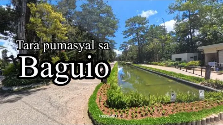
Key orientation points include Burnham Park, Session Road, Baguio Cathedral, and the Harrison Road Night Market area. If you are staying only one or two nights, this central base reduces the need for repeated cross-city transfers.
The trade-off is atmosphere. Central Baguio can be noisy, crowded, and congested, especially in the evening, on weekends, and during major events. It is also hilly, so do not assume that every nearby place is an easy walk. Some routes are short but tiring.
Camp John Hay and the Forested Side of the City
Camp John Hay suits travelers who want a greener, calmer side of Baguio. It has a more resort-style feel, with pine scenery, wider open spaces in some areas, and a stronger sense of retreat than the city center.
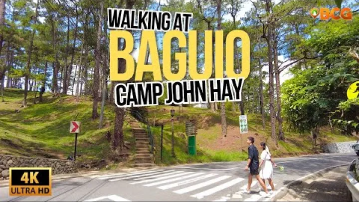
This area is a good fit for couples, families, remote workers on a short break, and travelers who value comfort and quiet over immediate access to markets and nightlife. It is also useful if your idea of Baguio includes relaxed walks, coffee, and time away from the busiest roads.
The main trade-off is logistics. If you stay around Camp John Hay, you will usually rely on taxis or a private vehicle for Session Road, Burnham Park, the night market, and northern attractions. It can feel calm, but it is not a guarantee of traffic-free travel.
Mines View, Botanical Garden, and the Northern Approach to La Trinidad
The northeastern and northern visitor corridors are useful for grouping popular stops into a half-day route. Baguio Botanical Garden, Mines View Park, and Good Shepherd Convent are often combined because they sit on the same general side of the city.

This route can continue toward places commonly added to a Baguio trip, including StoBoSa Valley of Colors and La Trinidad Strawberry Farm. These are associated with Baguio itineraries but are outside the central city experience and should be treated as nearby Benguet additions.
When visiting lived-in communities such as StoBoSa, be respectful. Do not block roads, photograph residents intrusively, or treat the area only as a photo backdrop. For La Trinidad, check current farm conditions before expecting strawberry picking, because availability can depend on season, weather, and local operations.
Best Time to Visit Baguio
Baguio can be visited year-round, but the experience changes with weather, festivals, holidays, and school breaks. The best time depends on whether you prefer cooler outdoor sightseeing, festival energy, or a quieter trip.
Seasonal Weather and What to Verify Before You Go
Baguio is generally cooler than many lowland Philippine cities because of its highland setting. That makes walking, park visits, and cafe stops more comfortable for many travelers, but it does not mean you need heavy winter clothing.
Cooler and relatively drier periods are usually more comfortable for outdoor sightseeing. Rainy months require more flexibility, especially if you plan viewpoints, gardens, or road trips beyond the city. Fog and rain can also affect visibility at places such as Mines View Park.
Check current forecasts close to your travel dates, especially during monsoon periods or when tropical cyclones may affect northern Luzon. Pack light layers, a rain jacket or umbrella, comfortable walking shoes, and clothing that can handle sudden changes between sun, mist, and rain.
Panagbenga, Holidays, and Crowd Timing
Panagbenga, Baguio's major flower festival, can make the city lively, colorful, and memorable. It can also make accommodation harder to book and traffic more difficult to manage, especially around parade dates and peak weekends.
Long weekends, Christmas, New Year, school breaks, and major local events can also significantly increase visitor numbers. If you want atmosphere, festival periods can be rewarding. If you want a calmer trip, choose weekdays or avoid peak event weekends when possible.
Before booking around a festival, verify current event dates through local tourism or city channels. Schedules, road closures, and crowd-control measures can change from year to year.
How to Get to Baguio
Most travelers reach Baguio by road. The main planning question is not only which route to take, but how much flexibility to leave for traffic, weather, terminals, and schedule changes.
Manila to Baguio by Bus or Private Vehicle
Road travel from Metro Manila is the most common approach. Buses are widely used by visitors who do not want to drive, while private vehicles are useful for families or groups that want more control over stops and luggage.
Bus operators may offer different service classes, terminals, and booking channels. For current schedules and tickets, check operators directly; for example, Solid North provides schedule and booking information through its official website.
Avoid planning around a fixed travel time. The road journey can vary depending on your departure point, traffic in Metro Manila, expressway conditions, weather, rest stops, road works, and peak travel periods. If you have a hotel check-in, dinner reservation, or return bus, leave extra buffer time.
Flights to Loakan Airport and Why You Should Verify Routes
Loakan Airport is in Baguio, but commercial flight access has been limited and has changed over time. Do not assume that flying directly to Baguio is available for your dates.
Because route availability can shift, verify flights directly with the airline before building your itinerary around Loakan Airport. A report from the Philippine News Agency illustrates how Baguio flight services have been subject to resumption and cancellation issues.
Unless a current flight is confirmed, road travel from Manila, Clark, or another Luzon gateway is the more dependable planning assumption. This is especially important for international travelers connecting from long-haul flights.
Using Baguio as a Gateway to the Cordillera
Baguio can work as a staging point for wider Cordillera travel, including nearby Benguet areas and more distant mountain destinations. It is a logical place to rest, adjust plans, and connect with onward transport.
However, not every Cordillera destination is an easy day trip from Baguio. Mountain roads, limited schedules, weather, landslides in some wider routes, and long travel times can affect plans. Treat Baguio city and deeper Cordillera travel as separate itinerary blocks.
If this is your first visit, spend at least one or two days in Baguio before moving onward. This prevents the common mistake of trying to combine city sights, La Trinidad, and far mountain destinations in one rushed schedule.
How to Get Around Baguio
Getting around Baguio is usually a mix of taxis, walking, jeepneys, and occasional private-vehicle use. The best option depends on your base, your budget, and how comfortable you are with local routes.
Taxis, Jeepneys, and Walking
Taxis are the easiest local transport option for many first-time visitors. Attractions are spread across hills, and taxis reduce the physical effort of moving between central Baguio, Camp John Hay, Botanical Garden, Mines View, and residential hillside areas.
Jeepneys are cheaper and widely used by residents, but routes can be less intuitive for visitors. If you use them, ask before boarding, carry small bills, and confirm the direction of travel. They are most useful when you are not in a rush and are comfortable with local public transport.
Walking works well in the central core, especially around Burnham Park, Session Road, Baguio Cathedral, and nearby dining streets. Still, Baguio is steep in many places. Allow time for uphill walks, wear shoes with good grip, and avoid planning long pedestrian routes during heavy rain.
Traffic, Parking, and Travel Time Buffers
Traffic is one of Baguio's main planning challenges. It can be manageable on some weekdays and difficult on weekends, holidays, festival dates, and rainy periods when movement slows down.
If you bring a private vehicle, check parking rules, accommodation parking availability, local advisories, and possible road closures. Do not assume that every attraction has easy parking, especially near central areas and popular viewpoints.
A simple rule helps: do not schedule too many cross-city moves in one day. Group nearby attractions, keep flexible meal plans, and leave generous buffers before bus departures, museum visits, or timed reservations.
Where to Stay in Baguio
Choose your Baguio base according to your trip style. Convenience, quiet, parking, weather access, and road steepness matter more than small differences on a map.
Best Base for First-Time Visitors
For short first-time trips, the Session Road and Burnham Park area is the practical default. It gives easy access to restaurants, taxis, shops, central landmarks, the market area, and evening activity around Harrison Road when available.
This base is especially useful if you arrive by bus or do not want to rent a car. It also makes it easier to take breaks during the day, which matters when rain or traffic disrupts plans.
Possible downsides include noise, older buildings, limited parking, and congestion. When booking, read recent reviews carefully for comments about street noise, cleanliness, ventilation, hot water, elevators, and access from steep roads.
Best Base for a Quieter Stay
Camp John Hay and selected residential hillside areas are better for travelers who want a quieter stay. These areas can suit families, couples, and visitors who are more interested in rest, greenery, and comfort than nightlife or market access.
The trade-off is less spontaneity. You may need taxis for meals, shopping, and central attractions. If you plan many early starts or late nights, confirm that transport will be practical from your accommodation.
Quiet areas are not always isolated, and they are not always free from traffic. Look at access roads, parking notes, and recent guest comments before booking, especially if you are traveling during peak dates.
Booking Tips for Peak Dates and Rainy Months
Book early for Panagbenga, Christmas, New Year, long weekends, and school-break periods. Central hotels and popular family-friendly stays can fill quickly when events draw visitors from Manila and nearby provinces.
During rainy months, consider flexible cancellation policies. Weather can affect road travel, sightseeing comfort, and outdoor attractions, so flexibility can be more valuable than a small discount.
International visitors should check details that may not be obvious from photos: heating or ventilation, hot water, luggage access on steep roads, parking, room noise, and whether the location is easy to reach by taxi after dark or in rain.
Best Things to Do in Baguio
The best Baguio activities combine classic landmarks with food, art, markets, and slower highland breaks. Do not treat the city as a race through photo stops.
Classic Parks, Viewpoints, and City Landmarks
Burnham Park is the central orientation point and a practical first stop for families, casual walks, and relaxed people-watching. Session Road and Baguio Cathedral are nearby, making them easy to combine in a central walking route.
Baguio Botanical Garden is useful for a greener break and can be grouped with the northeastern sightseeing corridor. Mines View Park is a classic viewpoint and souvenir stop, but visibility can depend on fog, rain, and the time of day.
These sights are popular because they are accessible and easy to understand, not because they are quiet. Visit early, keep your route simple, and expect crowds during peak periods.
Art, Culture, Cafes, and Local Food Stops
Baguio has a strong creative and food-oriented side. BenCab Museum and Tam-awan Village are common cultural additions, while cafes, artist spaces, and local markets give the trip more depth than a simple park-hopping route.
When visiting cultural or community-based spaces, use respectful language and behavior. Some places connect with Cordillera heritage and living communities, so treat them as more than decorative stops for photos.
Balance outdoor sightseeing with indoor breaks. Cafes, museums, and markets are useful during rain and also help slow the trip down. This is often when visitors enjoy Baguio most: over coffee, local food, art, and unhurried conversations.
Easy Day Trips Beyond the City
La Trinidad Strawberry Farm is one of the most common nearby additions to a Baguio itinerary, but it is in Benguet rather than central Baguio. StoBoSa Valley of Colors is another nearby stop often paired with La Trinidad or the northern route.
Plan these side trips with traffic, weather, and seasonal conditions in mind. Do not assume that strawberry picking is always available, and do not treat farm access as guaranteed without current local confirmation.
Wider Cordillera destinations need more planning than a casual half-day detour. If you want to go beyond nearby Benguet, add extra days and check onward transport carefully.
Suggested Baguio Itineraries
Use these itineraries as flexible frameworks. The goal is to reduce wasted movement, not to follow a strict timetable.
Two-Day Baguio Itinerary for First-Time Visitors
On the first day, focus on central Baguio. Start with Burnham Park, continue to Session Road for food or coffee, visit Baguio Cathedral, and leave time for the market area or Harrison Road Night Market if it is operating. Keep the evening flexible because rain and traffic can change the pace.

On the second day, do one main sightseeing circuit. A common route is Baguio Botanical Garden, Mines View Park, and Good Shepherd Convent, with meal breaks built in. If you prefer greenery over viewpoints, shift more time to Camp John Hay instead.
This two-day plan works best if you stay central or use taxis efficiently. Avoid adding La Trinidad, BenCab Museum, and multiple cross-city stops unless you are willing to cut something else.
Three-Day Baguio Itinerary with a Day Trip
With three days, keep the first day central and the second day for the Botanical Garden and Mines View side of the city. Use the third day for one theme: Camp John Hay and a relaxed meal, BenCab Museum and Tam-awan Village, or a nearby Benguet excursion such as La Trinidad.
If the weather is rainy, choose indoor or lower-effort alternatives. Museums, cafes, markets, and long meals can replace viewpoint-heavy plans. This keeps the trip enjoyable even when visibility is poor.
Do not use the third day to cram all missed sights into one long loop. Baguio rewards a slower pace, and the city becomes stressful when every hour depends on perfect traffic and weather.
DIY, Solo, Family, and Budget Adjustments
DIY travelers should group attractions by area and use taxis selectively. Jeepneys can reduce costs if you are comfortable asking about routes, but taxis may save time and energy on steep or unfamiliar roads.
Solo travelers should use normal urban caution: keep belongings secure, avoid poorly lit unfamiliar areas late at night, and confirm transport options before staying far from the center. Baguio is a popular visitor city, but common-sense planning still matters.
Families should limit transfers and build in rest stops. Budget travelers can save by staying central, mixing free or low-cost parks with one or two paid attractions, eating at casual local places, and avoiding peak dates when flexibility allows.
Final Planning Checklist: Costs, Safety, and Practical Tips
Before finalizing your Baguio trip, review the practical details that most often affect comfort: budget, weather, transport, safety, lodging access, and etiquette.
Typical Costs and Where to Save
Your main costs will usually be lodging, intercity transport, local rides, meals, entrance fees, shopping, and optional tours. Costs vary widely by season, comfort level, and how many paid attractions or taxis you use.
To save money, stay central enough to reduce unnecessary rides, group attractions by area, use jeepneys when you are comfortable, and mix paid stops with parks and viewpoints. Eating at casual restaurants, bakeries, markets, and local food spots can also keep daily spending controlled.
Avoid relying on fixed budget figures unless they are current. Prices for rooms, transport, and attractions can change, especially during holidays and festivals. Build a buffer for rain delays, extra taxi rides, and last-minute schedule changes.
Safety, Weather Disruptions, and Current Advisories
Use balanced safety planning. Protect your belongings in crowded areas, use normal urban caution at night, and keep copies of important documents if you are visiting from abroad. International travelers should also review national-level advisories, such as the U.S. Department of State travel advisory for the Philippines.
Weather can be a bigger trip disruptor than personal safety concerns. Heavy rain can affect walking routes, viewpoints, road travel, and wider mountain routes beyond Baguio. During storm-prone periods, monitor forecasts and avoid tight onward connections.
Do not assume that a simple city itinerary is immune to disruption. Road delays, parking issues, fog, and rain can all slow the day. Keep your most important activity early and leave optional stops for later.
Responsible Visitor Etiquette
Respect Baguio as a lived-in city, not only a tourist destination. Follow local rules in parks, markets, cultural sites, farms, and residential communities. Do not litter, block roads for photos, or ignore parking and traffic regulations.
At community-based or heritage-related places, ask before photographing people, support local businesses when appropriate, and follow site guidelines. At farms and gardens, stay on permitted paths and respect current access rules.
The simplest successful Baguio plan is also the most practical: choose the right base, verify transport and weather close to your dates, avoid overpacking the itinerary, and leave time for meals, coffee, rain pauses, and the city's slower highland atmosphere.
Select area
Create a post
Posting is free and no registration is required.