Hpa-An Travel Guide: Safety, Sights, Transport and Planning

This Hpa-An travel guide introduces one of southeastern Myanmar’s most distinctive landscapes: a flat plain framed by limestone peaks, cave-temples, pagodas, rice fields, and the Thanlwin River. For first-time travelers, the most important planning question is current access and safety, not simply which attraction to visit first. This guide separates current decision guidance from historical destination information and explains transport, places to stay, weather, costs, and a flexible itinerary model for a more stable future travel context.
Check Current Travel Conditions Before Planning Hpa-An
Hpa-An’s scenery remains the reason it has attracted travelers, but conditions can change more quickly than older travel guides, hotel pages, and route reports suggest. Make the travel-advisory decision before paying for transport or accommodation.
Current advisories and the decision to postpone
The most important first step is to read the latest advice from your own government. The U.S. Department of State page lists Burma at Level 4: Do Not Travel, with the cited advisory dated May 8, 2026. It identifies risks including armed conflict, unrest, arbitrary enforcement, limited health infrastructure, landmines or unexploded ordnance, and crime. Read the full U.S. Department of State advisory again immediately before making a decision, because an advisory date and its current wording are important.
A leisure visit to Hpa-An should not be presented as a normal Southeast Asia itinerary while national and regional conditions remain uncertain. A scenic attraction, a hotel listing, or a quiet report from a previous traveler cannot establish that Hpa-An town, its rural roads, caves, mountains, or surrounding villages are safe now. The same applies to routes from Yangon, Mawlamyine, or Myawaddy.
If your government advises against travel, the practical choice for a non-essential holiday is to postpone it. If you are considering travel for an essential reason, use the relevant official advice and professional local guidance to assess the specific risks rather than relying on a destination article. The landscape can be described separately from the current recommendation: Hpa-An may be an appealing future destination, but this guide cannot certify that a present visit is appropriate.
Separate historical guide information from current conditions
Much of what travelers know about Hpa-An comes from earlier, more stable travel conditions. Older reports describe road journeys, guesthouse-arranged day tours, motorbike circuits, cave visits, boat rides, mountain climbs, and hotel prices. Those accounts are useful for understanding the destination’s traditional character, but they do not prove that a road, attraction, border route, boat service, or accommodation is operating today.
Use historical information as a map of possibilities for a future trip, not as a live operating schedule. A booking page may remain online after services change, and a recent-looking review may describe a visit under conditions that no longer apply. Build any future plan so it can be postponed, shortened, or rearranged without losing money or depending on one unchangeable connection.
Understand Hpa-An's Setting and Travel Character
Hpa-An is best understood as a small town base for a wider rural landscape. Most of the area’s well-known sights are outside the center, so the experience depends as much on local transport and access as on the town itself.
Where Hpa-An fits in southeastern Myanmar
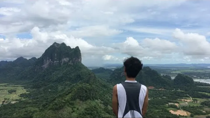
Hpa-An is the capital of Kayin State, on the eastern side of the Thanlwin, also called the Salween, River. Its setting combines a relatively flat, rice-growing plain with abrupt limestone formations. These isolated peaks and karst walls give the surrounding countryside its distinctive appearance and create the setting for many religious sites and caves.
For broad regional orientation, the Myanmar Ministry of Hotels and Tourism provides official Kayin State tourism context. In traditional travel planning, Hpa-An sat within a route between Yangon and Mawlamyine and was also associated with overland movement toward Myawaddy and Thailand. Those historic connections help explain its position on a map, but they should not be treated as dependable current transport links.
Keep the terms clear: Hpa-An town is the service and accommodation base, while the wider Hpa-An area includes rural roads, cave-temples, mountains, villages, pagodas, and river scenery. A plan that only considers the town center will miss the main landscape, while a plan that assumes every rural site is easy to reach may be too rigid.
Why travelers come: caves, peaks, and everyday landscapes
The traditional appeal of Hpa-An is the combination of experiences rather than one single monument. Travelers come for cave-temples with Buddhist images, limestone peaks, pagodas surrounded by fields or water, views across rice-growing country, and a slower atmosphere than Myanmar’s major tourist hubs. The Thanlwin riverfront and rural roads add lower-intensity options between more demanding visits.
Hpa-An is mainly a practical base for exploring the countryside, not a dense urban sightseeing destination. The town can be useful for meals, supplies, accommodation, and arranging transport, but many of the most memorable places are dispersed beyond the center. This makes the destination a better fit for travelers who enjoy landscapes, religious architecture, flexible days, and simple logistics than for visitors seeking extensive nightlife, museums, shopping, or a highly developed tourism network.
Older travel accounts also describe limitations such as basic infrastructure, fewer services, cash and connectivity constraints, and language barriers. These should not be romanticized as automatic authenticity or comfort. They are planning factors that affect communication, emergency arrangements, food choices, transport, and the ability to change plans.
How long to allow in a normal, stable travel context
Two to three nights was a traditional planning model for a first visit. It could allow time for arrival, a cave and pagoda circuit, one or two viewpoints, and slower periods beside the river or in the countryside. A short stay can work if the aim is a concentrated overview and transport is arranged efficiently.
A longer stay is more comfortable for travelers who want to avoid rushing between separated sites. An extra night can provide a buffer for a delayed arrival, poor weather, a tiring climb, or a change in local access. It can also make a town-center base more useful because the schedule does not need to be filled with long day trips.
This two- to three-night suggestion is a historical or future-stable framework, not a current recommendation. No duration should override travel advice, local movement restrictions, or a decision to postpone.
Explore Hpa-An's Main Sights
Hpa-An’s traditional sightseeing circuit mixes active religious places with outdoor viewpoints and quiet countryside. Treat the descriptions below as planning context, and allow the actual sequence to depend on access and local instructions.
Cave-temples: Sadan, Kawgun, and Yathaypyan
Sadan Cave is traditionally described as a large cave experience associated with a passage through the cave, a rural or rice-field setting, and a boat exit when water conditions and local services allow. The appeal is the change from a dark cave interior to an open landscape. A boat should never be assumed simply because an older itinerary includes one; ask locally whether the route, water level, boat, and return arrangements are available.
Kawgun Cave is known in travel descriptions for its dense Buddhist imagery and strong religious and heritage interest. It is better suited to travelers who want to look carefully at the relationship between the limestone setting and devotional art than to visitors seeking a purely geological walk. Avoid relying on unsupported dates or precise historical claims unless a dedicated heritage authority provides them.
Yathaypyan Cave is another traditional stop combining Buddhist images, cave chambers, and openings toward the surrounding landscape. The three caves should not be treated as interchangeable. Their visual character, approach, interior conditions, and the time needed to visit may differ.
All three are religious places. Wear clothing that covers shoulders and knees, remove footwear where local custom requires it, keep voices low, and do not touch images or decorations. Paths, caretakers, lighting, boats, and entry arrangements may vary, so do not describe an old cave report as proof of present availability.
Mount Zwegabin, Lumbini Garden, and Taung Wine Mountain
Mount Zwegabin is the defining peak in the Hpa-An landscape. In a stable travel context, the traditional attraction is the climb and the broad view over the plain. It is a physically demanding outing rather than a casual town walk. Heat, exposed sections, water needs, footwear, and the ability to descend safely should shape the decision more than the appeal of reaching a summit.

At the mountain’s base, Lumbini Garden is associated with rows of Buddha images and provides a lower-effort religious and photographic stop. The garden and the climb can be considered separately, which is useful for travelers with different fitness levels or limited time. Modest dress and respectful behavior remain important even when the site is being visited primarily for scenery.
Taung Wine Mountain is a separate viewpoint traditionally reached by road followed by a stair-based climb. Older accounts describe confusion about the correct trailhead, map directions, and construction or route changes. Ask a current local contact to identify the correct starting point rather than following an old map pin. Carry water, protect yourself from the sun, use secure footwear, and treat the physical route and its availability as separate questions.
Kyauk Ka Lat, Bat Cave, and the riverfront
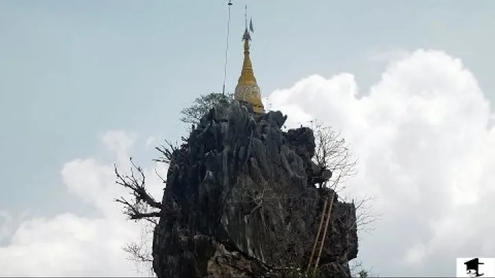
Kyauk Ka Lat Pagoda is a visually distinctive religious site set on a narrow rock formation surrounded by water or fields. Mount Zwegabin may form part of the wider view, which makes the location especially attractive for landscape photography. The setting can be appreciated without turning the visit into a rushed checklist, but visitors should follow local rules about access, footwear, clothing, and photography.
Bat Cave traditionally refers to an evening observation of bats emerging from the cave, not necessarily an underground cave visit. The experience depends on timing, the behavior of the bats, the viewing area, and arrangements for returning afterward. Do not assume that an old report’s timing or meeting point remains valid.
The Thanlwin riverfront, rural roads, rice fields, and sunset views offer lower-intensity alternatives to long climbs. They can provide space for a slower day or a backup plan when a strenuous outing is unsuitable. Boat rides, paths, evening transport, and return arrangements are variable, so make the end of the day part of the plan rather than an afterthought.
Get There and Move Around
Hpa-An’s attractions are spread across town and countryside, so transport planning is central to the experience. Older journey times and local arrangements are useful only as indicative background.
Intercity routes from Yangon and nearby hubs
Older accounts and an advertised Easybook listing show a Yangon to Hpa-An road connection. The listing gives approximately 290 kilometers and an indicative average travel time of 7 hours and 8 minutes. Treat those figures as listing data, not as a guarantee of a current departure, travel time, route, or safety. The page may also display fares or trips that are not available on the date you need.
Travelers have also traditionally connected Hpa-An with Mawlamyine as part of a southeastern Myanmar route. The former overland relationship between Hpa-An, Myawaddy, and Thailand is a separate historical possibility, not a default continuation. Border procedures, road access, checkpoints, cancellations, diversions, and local conditions can make old times and routes unusable.
Before paying, confirm the specific intercity route with a current operator and a local accommodation provider. Ask for the departure point, arrival point, travel date, cancellation terms, and what happens if the service is canceled or diverted. A booking page can show that a route was advertised without proving that it will operate for your journey.
Tuk-tuks, motorbikes, drivers, and day tours
Traditional local options include tuk-tuks for short journeys and full-day circuits, motorbikes for independent exploration, and drivers or day tours arranged through a guesthouse. Because caves, pagodas, and viewpoints are separated by rural roads, a local driver can simplify navigation and reduce the number of separate arrangements.
A tuk-tuk or private car is usually the simpler choice for travelers who want to combine several distant stops, carry water, or avoid navigating unfamiliar roads. A motorbike offers more flexibility for experienced riders, but it also brings exposure to road quality, weather, navigation errors, limited roadside assistance, and the consequences of being far from town. Do not treat an old rental price or tour rate as a current quote.
Choose transport according to the day’s distance, your physical ability, weather, communication needs, and the availability of a reliable return plan. Ask what is included in a driver or tour arrangement, including waiting time, fuel, entrance or boat-related charges, and the point where the service ends.
Route verification, maps, and returning before dark
Minor roads and trailheads may be poorly signed, and older accounts describe inaccurate map directions around places such as Taung Wine Mountain. Carry offline maps and physical contact details, but treat a map pin as a starting point rather than proof that a road, trail, or site is accessible.
Before setting out, ask a current local contact to confirm the destination, road, trailhead, attraction status, and a feasible return route. Avoid improvising into restricted or unfamiliar rural areas merely because a blog or map suggests that a route exists. Plan the return before beginning a hike, cave visit, or sunset outing, especially when the day involves several separate stops.
- Confirm the exact destination name and road with your driver or accommodation.
- Record the driver’s name, phone number, vehicle details, and agreed return time.
- Ask whether the intended attraction and any boat or trail connection are available.
- Carry offline directions and the accommodation’s physical address or local-language contact details.
- Set a clear turnaround time and identify a simpler alternative if the route cannot be completed.
Build a budget without relying on outdated prices
Old Myanmar kyat prices and online figures can quickly become misleading because inflation, exchange-rate changes, service disruption, and availability affect the real cost of a trip. A price shown in a historical blog or booking page should not be converted into a fixed promise in dollars, euros, or another currency.
Build the budget by category rather than by copying an old total. Include accommodation, intercity transport, local driver or tuk-tuk hire, motorbike rental and fuel if available, meals, cave or boat-related charges, communications, and an emergency buffer. For a rural day, ask whether the quoted transport covers waiting, return travel, and all planned stops.
Request current quotes in local currency before accepting a room, transfer, tour, boat, or vehicle. Clarify what is included, when payment is due, and whether the price changes for a shorter or longer route. Keep a payment backup because connectivity, card acceptance, or access to cash may not be consistent, but do not assume a particular banking arrangement without checking locally.
Choose the Right Place to Stay
The main accommodation decision is between convenience in Hpa-An town and a quieter scenic base outside the center. The best choice depends on transport, services, pace, and how much landscape time you want.
Town center for convenience
The central Hpa-An area has traditionally been the practical base for markets, simple eateries, riverfront access, guesthouses, and arranging local transport. It suits short stays, first-time visitors, travelers without a motorbike, and anyone who prefers to solve meals, supplies, and onward transport close to town.
A central location does not necessarily mean higher hotel quality or easy walking access to every attraction. The town is more functional than monument-focused, while the major caves, mountains, and pagodas are generally part of the surrounding countryside. Choose the center for logistics and services, not because it places every sight outside your door.
Online accommodation pages can show the range of properties associated with Hpa-An. For example, Agoda lists examples such as My Hpa-An Residence by Amata, Zwekapin Valley Resort and Spa, and Keinnara Hpa-An. Such listings are examples for comparison only; they do not confirm that a property is operating, accepting your type of booking, or providing the services shown.
Scenic outskirts and Mount Zwegabin-area stays
Rural-fringe resorts and lodges can offer views, rice-field scenery, quiet surroundings, and a stronger connection to the karst landscape. They may suit travelers who prioritize atmosphere, photography, and an unhurried setting over spontaneous access to town.
The trade-off is practical. An out-of-town stay can mean fewer walkable services, greater reliance on a tuk-tuk or private transfer, limited connectivity, and more complicated evening logistics. A quiet location is not automatically safer, and being farther from town can make an unexpected departure or supply run more difficult.
Ask the property about meals, electricity, water, communications, transport support, reception hours, and emergency departure arrangements. Confirm how long it takes to reach town under current conditions and whether the property can help arrange a driver for dispersed attractions. Select a scenic base only if you are comfortable with those limits.
Flexible booking and accommodation verification
An online listing, recent review, or old travel blog cannot by itself confirm current operations in a changing environment. Contact the property directly before making a non-refundable commitment. Keep the accommodation decision secondary to the national and regional travel-advisory decision.
Useful questions include:
- Are you open on my exact dates, and are you accepting the type of traveler and payment I will use?
- Are water, electricity, mobile connection, meals, and reception services available?
- Can you confirm current access from my arrival point and help arrange transport if needed?
- Which planned roads, attractions, caves, or viewpoints can local staff currently confirm?
- What are the cancellation, payment, and refund terms if transport or access changes?
Prefer flexible or cancellable arrangements where they are available. Do not build a non-refundable multi-stop itinerary around Hpa-An before the wider travel decision and the specific local access arrangements are clear.
Choose a Season for Weather and Outdoor Activities
Weather matters because Hpa-An’s traditional highlights involve exposed climbs, cave approaches, rural roads, and outdoor viewpoints. Climate should remain a secondary factor after travel conditions and confirmed access.
Dry, hot, and rainy periods
The broad historical pattern is a drier period around December to February, a hotter period around March and April, and a wetter monsoon period from roughly May to October. These are general seasonal descriptions, not a current forecast for a particular travel date.
The drier months traditionally offer clearer views and easier road or trail conditions. The hotter period can make climbs more demanding, especially on exposed limestone slopes and stair routes. The wet season may produce greener rice fields and strong landscape colors, but rain can make paths slippery and can disrupt rural travel, cave approaches, or boat-related plans.
There is no responsible single best time to visit if the route or destination is not appropriate under current conditions. Favorable weather cannot make an unsafe journey suitable. Use a current forecast for the dates under consideration rather than relying on a seasonal label alone.
Plan hikes and cave visits around conditions
Heat affects climbs such as Mount Zwegabin and Taung Wine Mountain. If travel becomes appropriate and the route is locally confirmed, plan demanding outings for the cooler part of the day, carry enough water, use sun protection, and wear footwear with secure grip. Early starts can reduce heat exposure, but they do not remove the need to assess the route or your ability to return.
Rain can make limestone steps, cave approaches, dirt roads, and viewing areas slippery. It may also change access to a boat exit or make a road unsuitable for a small vehicle. Check a current forecast and obtain a local trail or cave condition update before each active outing. If conditions deteriorate, replace a climb or cave circuit with a shorter, lower-exposure plan rather than trying to complete the original schedule.
Use seasonality as a secondary planning factor
Route openness, transport reliability, local guidance, and the wider travel decision matter more than choosing the most comfortable weather month. If travel becomes appropriate, use flexible dates and a buffer instead of a tightly sequenced schedule that depends on clear skies or one boat connection.
A weather-sensitive plan can be simplified by choosing fewer active sites and leaving time for town, the riverfront, or rural scenery. That approach reduces the number of exposed climbs and makes it easier to change the day without losing the purpose of the visit.
Build a Flexible Hpa-An Itinerary
An itinerary for Hpa-An works best as a set of decisions rather than a fixed list of reservations. The framework below describes a historical or future-stable visit and should be adjusted to confirmed access, weather, transport, and physical ability.
A two- to three-night framework for future stable conditions
For a two- to three-night stay, use the first day mainly for arrival, settling into the town or chosen base, and a simple orientation. Avoid placing a demanding climb immediately after a long intercity road journey. If energy, weather, and local access allow, a short town or riverfront activity can provide context without committing the entire day.
Use one full day for a cave and pagoda cluster, choosing among places such as Sadan Cave, Kawgun Cave, Yathaypyan Cave, or Kyauk Ka Lat according to the route that can be confirmed. Use another day for Mount Zwegabin or Taung Wine Mountain if the trail is suitable, with Lumbini Garden or countryside scenery as a separate option rather than an automatic addition.
Keep one uncommitted half-day where possible. It can absorb a delayed arrival, weather change, slow transport, or a decision to visit fewer sites. This is a planning model, not a current recommendation to travel, and no fixed daily route should take priority over local instructions.
Match the base and pace to your priorities
Choose the base and pace that match the experience you want. An active plan requires more transport coordination and leaves less room for changes. A lower-exertion plan can still include Hpa-An’s distinctive scenery without treating every peak and cave as essential.
| Travel style | Main focus | Planning needs |
|---|---|---|
| Active | Mountains, dispersed caves, and longer rural days | Reliable transport, water, footwear, weather buffer, and a return plan |
| Lower exertion | Pagodas, river views, rice fields, town time, and shorter outings | Central or convenient base, shorter transfers, and flexible alternatives |
| Landscape-focused | Scenic outskirts, viewpoints, and slow countryside time | Quiet accommodation, meals, communications, and evening transport |
A town-center base supports easier logistics, while a scenic fringe stay prioritizes landscape and quiet. In either case, plan fewer sites well rather than assuming every named attraction can be completed in one or two days.
When to combine Hpa-An with Mawlamyine or another stop
Hpa-An has traditionally formed part of a southeastern Myanmar corridor that could include Mawlamyine or other regional stops. Combining destinations may make sense when the relevant roads, schedules, accommodation, and onward connections are confirmed. It also increases the number of points at which a change can affect the whole itinerary.
The Myawaddy and Thailand connection should be treated as a separate, highly conditional transport question. Older itineraries do not prove that a border crossing or overland continuation is available for your dates. If regional movement cannot be confirmed, a simpler single-base plan is easier to adjust than a multi-stop loop.
Final Takeaway: Plan for Flexibility, Not Certainty
Hpa-An’s traditional travel appeal comes from the relationship between town and countryside: cave-temples, limestone peaks, Kyauk Ka Lat, Bat Cave, Mount Zwegabin, Lumbini Garden, river views, and rice fields all form part of a wider landscape rather than a compact city checklist. A future-stable visit would usually benefit from two or three nights, a practical base, local transport support, and time for weather or route changes.
The essential planning principle is to separate destination interest from present travel permission and access. Read current official advice first, treat older routes and prices as historical, confirm accommodation and transport directly, and keep the itinerary flexible. If those conditions cannot be established, postponing the trip is more responsible than forcing certainty onto an uncertain route.
Select area
Create a post
Posting is free and no registration is required.